
Thermal imaging can be used in all fields where temperature differences help analyse an area or an object. It is a relatively new technology in agriculture, but it is quickly gaining popularity. As the cost of thermal cameras continues to decrease, and as more farmers become aware of the benefits of thermal imaging, it is likely to become an essential tool for many farmers in the future. When used in agriculture, it helps a lot in plant disease detection, yield estimation, evaluating the maturity of the crop, water stress estimation, irrigation scheduling, as well as fertilization planning. Currently, there is not much work being done in the field of combining thermal and multispectral images through machine learning. However, the fact is that by using both technologies, more comprehensive data can be obtained, and potential errors that may arise from using only one technology can be identified. Nevertheless, for more complex research, both thermal and multispectral imaging are used seamlessly, and the gathered information, especially for thermal, is processed manually.

Variable rate application (VRA) maps without guided navigation system
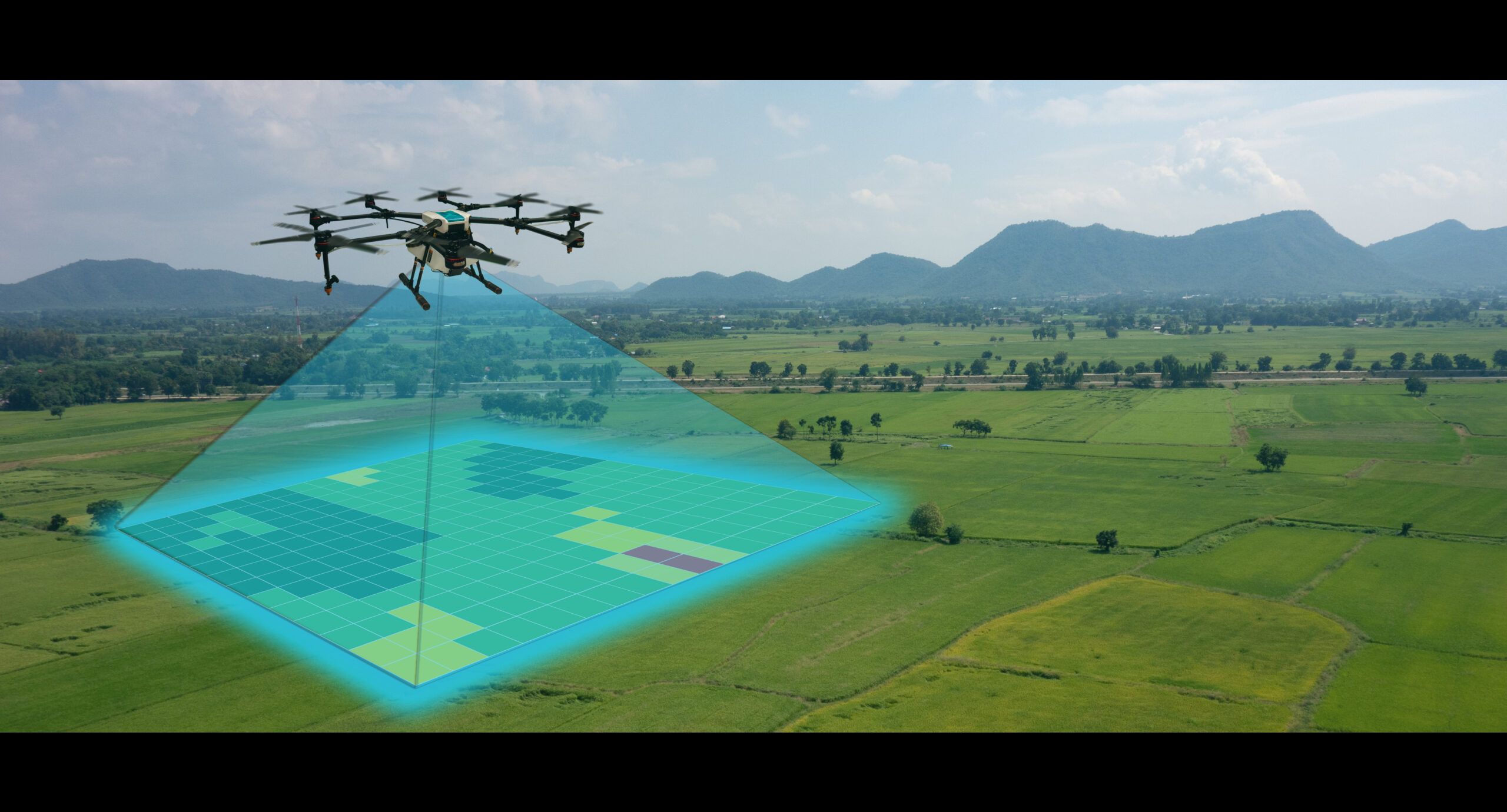
Variable rate application (VRA) maps can still be useful even without navigation, depending on the specific context and goals of their use. VRA maps are designed to guide agricultural machinery, such as tractors or sprayers, in applying inputs (e.g., fertilizers, pesticides) at variable rates across a field. The purpose is to optimize the use of resources and inputs based on the variability of soil and crop conditions within the field. There are cases where VRA maps can be useful even without guided navigation: Pre-Planning: Farmers and agronomists can create VRA maps based on historical data, soil sampling, satellite imagery, or drone surveys. These maps help determine the optimal application rates for different areas of the field before actual application begins. Manual Application: In situations where navigation systems are not available or practical, farmers can manually follow VRA maps’ guidelines to apply inputs at varying rates using their knowledge and experience. Small-Scale Operations: For smaller farms or areas where the use of GPS-based navigation systems is not feasible or economical, VRA maps can be used to guide manual variable-rate application. Non-Precision Applications: Some agricultural machinery may not have advanced navigation capabilities, but they can still make use of VRA maps to adjust input rates manually as they move across the field. Research and Analysis: VRA maps can be utilized in research studies and data analysis to assess the effectiveness of variable-rate applications and identify trends or patterns in field variability. However, it’s essential to note that while VRA maps without navigation can provide benefits, the full potential of variable-rate application is realized when it is combined with precision agriculture technologies, including GPS-guided navigation. Navigation systems enable real-time adjustments and ensure precise execution of VRA prescriptions, maximizing efficiency, and minimizing input waste. As technology continues to advance, integrating navigation capabilities with VRA maps is becoming more accessible and cost-effective, enabling farmers to achieve greater precision and efficiency in their agricultural practices.

What is greenseeker sensor
The GreenSeeker sensor is an agricultural technology device used to optimize the application of fertilizers in crop fields. It measures the variability of crop vigor or “greenness” within a field and provides real-time data to help farmers make informed decisions about fertilizer application rates. The GreenSeeker sensor operates based on the principle that plants reflect and absorb light differently depending on their health and nutrient status. It emits light in the near-infrared (NIR) spectrum and measures the amount of reflected light. By analyzing the reflected light, the sensor can assess the overall health and vigor of the crops. Farmers typically mount the GreenSeeker sensor on a tractor or other farm equipment and drive it through the fields. As the sensor moves, it collects data on the crop’s reflectance and transmits it to a computer or handheld device for analysis. The data is then used to create a vegetation index, such as the normalized difference vegetation index (NDVI), which quantifies the level of crop vigor. By mapping the variability of crop vigor across the field, farmers can identify areas that require more or less fertilizer. This allows for site-specific fertilization, where the application rates can be adjusted according to the specific needs of different parts of the field. It helps optimize fertilizer usage, reduce costs, and minimize environmental impacts by avoiding excessive fertilizer application. Overall, the GreenSeeker sensor is a valuable tool for precision agriculture, enabling farmers to make data-driven decisions and improve resource efficiency in their crop production.

How tractors use prescription maps
Tractors can use prescription maps in a few different ways to optimize their operations and improve efficiency. Prescription maps are essentially maps that provide specific recommendations for variable rate application of inputs, such as fertilizers, herbicides or seeds-based on variations in soil properties or other factors within a field. GPS Guidance: Tractors equipped with GPS technology can use prescription maps to guide their movements within the field. The prescription map provides instructions on where to apply different input rates based on the specific needs of different areas. The tractor’s guidance system uses the map to steer and control the application equipment accurately. Variable Rate Technology (VRT): Tractors with VRT capabilities can adjust the application rates of inputs in real-time based on the prescription map. The map provides information on the varying requirements of different zones within the field. The tractor’s VRT system automatically adjusts the flow rates or application rates of inputs, ensuring that the right amount is applied precisely where needed. Section Control: Tractors can use prescription maps in conjunction with section control systems. Section control allows the tractor to turn on and off specific sections of the implement, such as sprayers or planters, to avoid overlapping or applying inputs where they are not needed. Prescription maps can be integrated with the section control system to automatically control the sections based on the specific recommendations of the map. Data Collection and Analysis: Tractors equipped with precision agriculture technology can collect data while operating in the field, such as soil moisture levels, crop health, or yield data. This data can be combined with the prescription maps to analyze the effectiveness of the applied inputs and make adjustments for future operations. Overall, prescription maps enable tractors to implement precision agriculture techniques, optimizing input usage and increasing productivity by applying inputs in a site-specific manner. By using these maps, tractors can help farmers achieve more efficient and sustainable farming practices.

How precision farming saves money
Precision farming refers to the use of advanced technologies, such as GPS, remote sensing, and data analytics, to optimize agricultural practices. This approach offers several ways to save money in agriculture: Targeted resource application: Precision farming enables farmers to apply resources, such as water, fertilizers, and pesticides, precisely where and when they are needed. By utilizing data from remote sensing, soil sensors, and yield monitors, farmers can identify variability within their fields and create prescription maps for targeted application. This reduces waste by avoiding unnecessary applications in areas that don’t require them, leading to cost savings on inputs. Improved crop management: Precision farming techniques provide detailed information about crop health, growth, and development. By monitoring crop conditions in real time, farmers can make informed decisions regarding irrigation schedules, pest management, and nutrient application. Optimizing these practices based on accurate data can result in increased crop yields and reduced production costs. Reduced machinery and labor costs: With precision farming, farmers can use automated guidance systems and GPS technology to optimize machinery operations. This leads to improved efficiency in tasks such as planting, spraying, and harvesting, reducing overlaps and minimizing wasted inputs. Additionally, by leveraging data analytics and remote monitoring, farmers can make better-informed decisions without the need for manual scouting, thereby reducing labor costs. Prescriptive maintenance: Precision farming technologies can also facilitate proactive equipment maintenance. By utilizing sensors and telematics, farmers can monitor the performance of their machinery, detect potential issues, and schedule maintenance before major breakdowns occur. This approach minimizes costly downtime and repairs while extending the lifespan of agricultural equipment. Enhanced yield forecasting: Accurate and real-time data obtained through precision farming techniques enables farmers to make more accurate yield forecasts. This information is valuable for marketing, pricing, and budgeting purposes. By having a better understanding of potential yields, farmers can optimize their selling strategies, negotiate better prices, and plan their financial resources more effectively. Overall, precision farming optimizes agricultural operations by minimizing resource waste, maximizing productivity, and making informed decisions. These cost-saving benefits contribute to more efficient and sustainable farming practices.

Why are reflectance panels must have for multispectral drone operators
A multispectral reflectance panel, also known as a reflectance calibration target or color calibration target, is a specialized tool used in remote sensing and imaging applications. It is designed to have known and stable reflectance properties across multiple spectral bands or wavelengths. The panel consists of a flat surface divided into several patches, each with a different known reflectance value. These reflectance values are typically measured or calibrated using a spectrometer or other specialized instruments. Multispectral reflectance panels are used to calibrate remote sensing instruments, such as satellites or airborne sensors, to ensure accurate and consistent measurements of the Earth’s surface. By imaging the panel under controlled conditions, the instrument can compare the measured reflectance values of the panel’s patches to their known values. This allows for adjustments and calibration of the instrument’s measurements, compensating for any variations or biases. The panels are often constructed to have high reflectance uniformity and stability over time. They can be made using various materials, such as specially designed paints, ceramics, or polymers, depending on the spectral range of interest. Multispectral reflectance panels are crucial for maintaining the accuracy and reliability of remote sensing data, enabling researchers to compare and analyze images acquired at different times or from different sensors. They play a vital role in applications such as environmental monitoring, agriculture, land cover mapping, and scientific research.
Satelite vs drone multispectral imagery
Drones and satellites both have significant applications in agriculture and can be used for various purposes. The comparison by categories is listed below: Coverage and Scale: Satellites have the advantage of covering large areas of land in a single pass. They can capture images of vast agricultural regions, making them suitable for monitoring large-scale crop growth and analyzing regional trends. Drones, on the other hand, are more suitable for smaller farms or localized areas where high-resolution imagery is required. Spatial and Temporal Resolution: Drones provide higher spatial resolution imagery compared to satellites. They can capture detailed images from low altitudes, enabling farmers to identify specific plant stress, pests, diseases, or nutrient deficiencies on individual plants. Satellites offer lower spatial resolution but compensate with more frequent revisit times. Depending on the satellite, they can capture images every few days to weeks, allowing for monitoring changes in vegetation over time. Flexibility and Adaptability: Drones offer greater flexibility as they can be easily maneuvered and flown on-demand. This allows farmers to target specific areas of interest, collect data at specific times, and respond quickly to changing conditions. Satellites, on the other hand, follow a predefined orbit and may not provide real-time or immediate data acquisition. However, they offer consistent monitoring over time, providing a historical perspective. Cost: Drones are generally more cost-effective for smaller areas and localized operations. They are relatively affordable and can be operated by farmers themselves. Satellite imagery, on the other hand, can be expensive, especially if high-resolution data or specialized analysis is required. However, satellite imagery providers are continuously improving their services and making data more accessible and affordable. Accessibility: Satellite imagery is accessible to anyone with an internet connection, and data can be easily obtained from various providers. Drones require initial investment in equipment and training, and regulatory requirements may apply, such as obtaining permits and adhering to flight restrictions. In practice, a combination of both drones and satellites can offer comprehensive monitoring and analysis in agriculture. Drones can provide detailed information at a local scale, while satellites provide a broader perspective and historical data. Farmers and agricultural professionals can use drones for precise scouting and immediate action, and satellite imagery for long-term analysis, regional trends, and large-scale management decisions.
General information about multispectral technology
Multispectral imaging is a technique used to capture and analyze images at multiple wavelengths across the electromagnetic spectrum. Instead of capturing images in just the visible light range, multispectral imaging extends the range of wavelengths to include infrared (IR) and ultraviolet (UV) regions as well. By capturing images at different wavelengths, multispectral imaging allows for the detection and analysis of information that may not be visible to the human eye alone. Different materials and objects interact with light in unique ways, and by examining their responses at different wavelengths, multispectral imaging can provide valuable insights and data about these objects. Multispectral imaging is widely used in various fields, including remote sensing, astronomy, environmental monitoring, agriculture, archaeology, and medical imaging. It enables researchers and professionals to identify and study specific features, patterns, or anomalies that may be invisible or difficult to detect using conventional imaging techniques. The process of multispectral imaging involves using specialized cameras or sensors that are capable of capturing light at specific wavelengths or within specific wavelength ranges. These cameras often employ filters or spectrometers to isolate the desired wavelengths of light. The captured multispectral data can then be analyzed and processed using various algorithms and techniques to extract meaningful information or enhance certain features of interest. Overall, multispectral imaging offers a powerful tool for exploring and understanding the world around us by providing a broader perspective of the electromagnetic spectrum beyond what the human eye can perceive.
