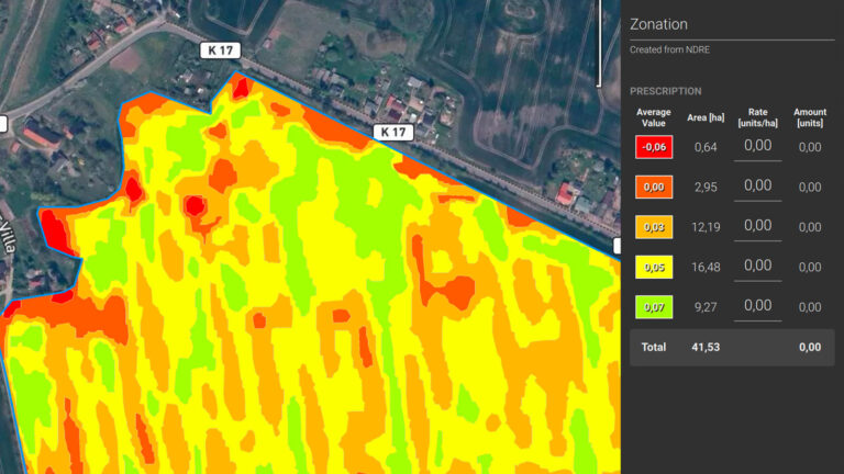
Tractors can use prescription maps in a few different ways to optimize their operations and improve efficiency. Prescription maps are essentially maps that provide specific recommendations for variable rate application of inputs, such as fertilizers, herbicides or seeds-based on variations in soil properties or other factors within a field.
- GPS Guidance: Tractors equipped with GPS technology can use prescription maps to guide their movements within the field. The prescription map provides instructions on where to apply different input rates based on the specific needs of different areas. The tractor’s guidance system uses the map to steer and control the application equipment accurately.
- Variable Rate Technology (VRT): Tractors with VRT capabilities can adjust the application rates of inputs in real-time based on the prescription map. The map provides information on the varying requirements of different zones within the field. The tractor’s VRT system automatically adjusts the flow rates or application rates of inputs, ensuring that the right amount is applied precisely where needed.
- Section Control: Tractors can use prescription maps in conjunction with section control systems. Section control allows the tractor to turn on and off specific sections of the implement, such as sprayers or planters, to avoid overlapping or applying inputs where they are not needed. Prescription maps can be integrated with the section control system to automatically control the sections based on the specific recommendations of the map.
- Data Collection and Analysis: Tractors equipped with precision agriculture technology can collect data while operating in the field, such as soil moisture levels, crop health, or yield data. This data can be combined with the prescription maps to analyze the effectiveness of the applied inputs and make adjustments for future operations.
Overall, prescription maps enable tractors to implement precision agriculture techniques, optimizing input usage and increasing productivity by applying inputs in a site-specific manner. By using these maps, tractors can help farmers achieve more efficient and sustainable farming practices.
